Title: Original 1947 Map of South Africa by Charles Burki – Jan van Riebeeck & Cape Colony
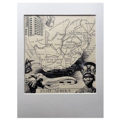
This striking 1947 pen-and-ink map of South Africa by Charles Burki (1909–1994) exemplifies his refined draughtsmanship and his ability to fuse cartographic precision with artistic flair. Executed shortly after World War II, this piece celebrates both geographical and historical narratives, featuring an elegant portrait of Jan van Riebeeck (1618–1677), founder of the Dutch Cape Colony, and intricate illustrations of the region’s landscapes, minerals, and produce.
The map traces the major territories and cities of southern Africa—Cape Town, Kimberley, Johannesburg, Durban, Bloemfontein, and Port Elizabeth—outlined with meticulous linework and labelled in Dutch. Decorative details include a radiant diamond motif representing the mines of Kimberley, grapevines and fruit clusters symbolizing agricultural wealth, and a compass rose rendered with Burki’s characteristic precision. The Kalahari Desert, the Zwarte Bergen, and the Cape of Good Hope are drawn with expressive shading, emphasizing the continent’s natural grandeur.
In the upper left corner, Burki depicts Jan van Riebeeck in a neoclassical vignette style, commemorating the Dutch founder of Cape Town. The lower right bears Burki’s signature and the date “’47,” placing it among his early postwar works for Dutch publishers such as *Uitgeverij Succes* and *Shell Wereldkaarten*, which sought to educate through beautifully illustrated maps.
Charles Burki’s personal story gives this map particular poignancy. Born in the Dutch East Indies, he lived through the horrors of World War II, enduring years of imprisonment under Japanese occupation. He survived the sinking of a Japanese transport ship and later witnessed the atomic bombing of Nagasaki. Emerging from these ordeals, Burki resettled in the Netherlands, channeling his experience into a disciplined and purposeful art style defined by clarity, structure, and quiet optimism. His postwar maps—precise yet expressive—reflect both technical mastery and resilience.
This 'Zuid-Afrika' map embodies Burki’s postwar vision: balance, order, and reverence for history and geography. The work captures a transitional era when global awareness and education merged with mid-century design aesthetics. Its combination of Art Deco lettering, documentary accuracy, and subtle idealism make it a rare example of educational art from the late 1940s.
Condition report: Very good condition with light toning and minor handling traces. A few small edge creases and mounting tape marks consistent with archival presentation. Ink remains strong and contrast crisp.
Framing suggestion: A dark wood or black frame with an ivory mat will highlight the dramatic black-and-white composition and period typography.
Technique: Pen and ink on paper
Maker: Charles Burki (Dutch-Indonesian, 1909–1994), signed and dated 1947