Antique Map of Raja Ampat and New Guinea, Bellin, Papuan Islands c.1749
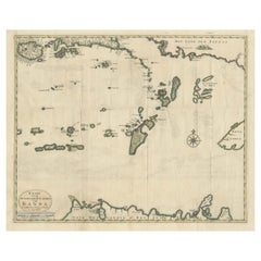
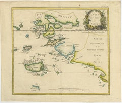
This refined and historically significant 18th-century map of the Papuan Islands was engraved by the eminent French hydrographer Jacques-Nicolas Bellin and published in Paris circa 1748–1749 as part of Abbé Prévost’s celebrated Histoire Générale des Voyages. It presents one of the earliest detailed European cartographic renderings of the Raja Ampat archipelago and the western extremity of New Guinea, a region of immense importance during the height of the global spice trade.
The composition centers on the intricate island networks of Waigeo (Terre de Waigeew), Salawati (Sallawatty), and Misool (Mixoal), alongside the adjacent coastlines of New Guinea (Terre de Papous) and Ceram. Bellin’s rendering captures the fragmented geography of this maritime landscape with remarkable clarity, depicting narrow straits, scattered islets, and navigational routes that would have been critical to European explorers and traders operating in the East Indies.
The map is elegantly enhanced with original hand coloring, delicately outlining coastlines in soft greens and yellows, adding both visual depth and decorative appeal. In the upper right, a finely engraved rococo cartouche provides the title, adorned with stylized foliage, reflecting the artistic sophistication characteristic of mid-18th-century French cartography. The equatorial line is clearly marked, emphasizing the map’s scientific intent alongside its aesthetic qualities.
Bellin, appointed Hydrographer to the French Navy, was among the most respected cartographers of his time, and his work formed the backbone of many major European travel accounts. Maps such as this were instrumental in shaping European understanding of Southeast Asia and the Pacific, particularly regions that remained only partially explored.
Today, this map holds strong appeal for collectors of early Indonesian cartography, maritime history, and decorative works on paper. Its balance of geographic importance and refined design makes it equally suitable for scholarly collections and high-end interior display.
This is an original 18th-century engraving, not a reproduction. All items we offer are authentic period works of art over 100 years old. The print is sold unframed; any framed images are shown for presentation and interior inspiration only and not always on scale in the visual presentation.
Condition: Good overall condition for its age, with light age toning and minor handling wear consistent with 18th-century paper. Original fold lines as issued. Colors remain fresh and attractive. Plate mark visible.
Framing tips: This map benefits from a dark walnut or ebonized frame combined with a wide ivory or warm off-white mat to enhance contrast and bring out the hand coloring. For a more regional aesthetic, it also works exceptionally well in a warm, textured interior setting inspired by Indonesian or coastal design, where the soft tones of the paper complement natural materials.
Technique: Copper engraving with original hand coloring
Maker: Jacques-Nicolas Bellin, Paris, circa 1748–1749
Keywords: Raja Ampat map, Papua New Guinea...
Category
Antique Mid-18th Century French Maps